


Defeated by Mao Zedong's Communist forces on the Chinese mainland and forced into retreat on Taiwan, Chiang Kai-shek's government-in-exile never gave up its claims to the mainland as long as the Generalissimo lived - and little has changed since then.
Only in 2012 did Taipei finally recognize the independence of Mongolia, and until the mid-2010s maps published in Taiwan depicted mainland provincial and national boundaries as they were in 1949, disregarding changes made by the Communist administration after 1949.
EXPLAINER: How every Chinese province really got its name
In 1951, the ROC Ministry of the Interior released this map entitled the "Provincial Adjustment Draft Plan" as a part of its "Plan for Provincial Adjustments Following Recovery of the Mainland."
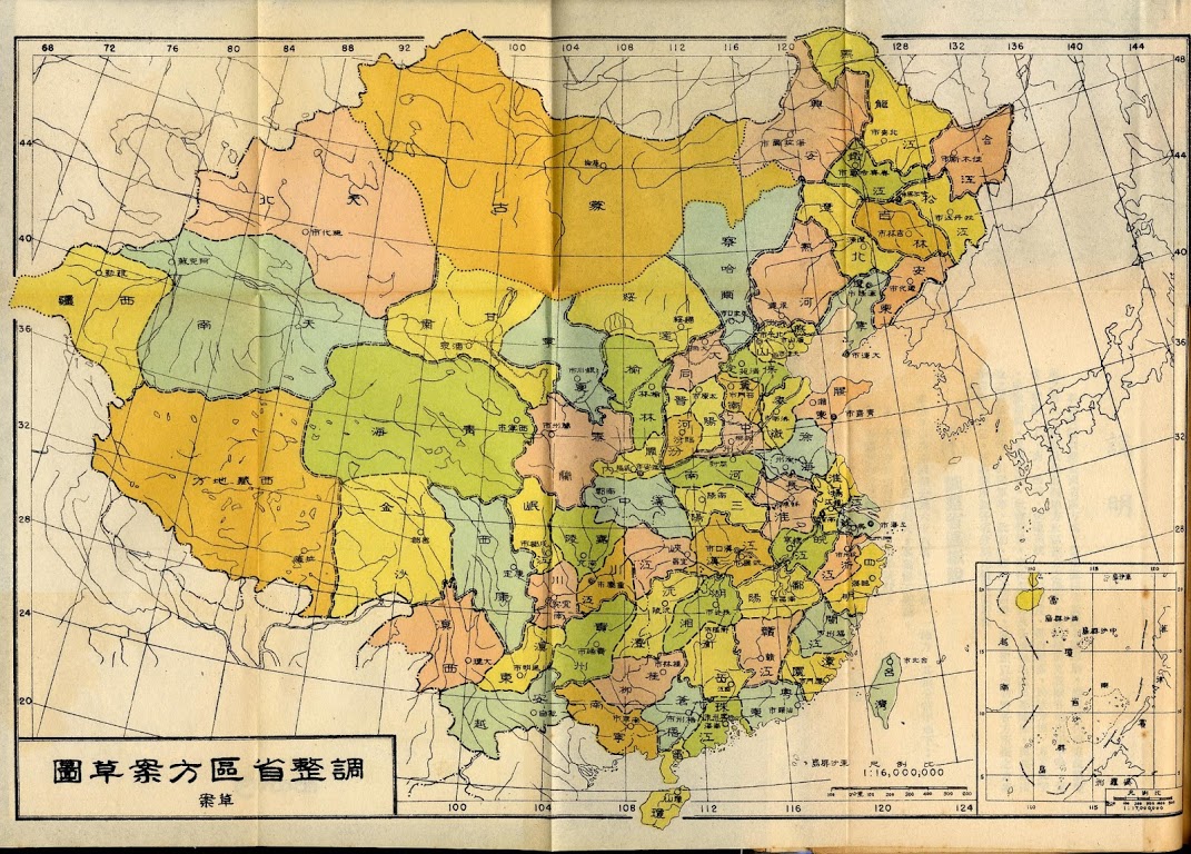
"Provincial Adjustment Draft Plan"
Under the proposed new administrative subdivision, the Republic of China's 35 provinces and two autonomous regions would nearly double in number, carved up into 68 new provinces drawn up along largely linguistic lines.
DON'T MISS: This WWII-era map of China just might change the way you view the country
Although not every new border necessarily marks the division between Sinitic languages or dialects, this is often the case. Guangdong is carved into three new units, for example: Peal River Province, where Guangzhou dialect Cantonese predominates, hemmed in by Leikiung Province comprising the Leizhou Peninsula and Hainan, where locals speak the Leizhou and Qiongwen Min varieties, and Eastern Yue, which begins where the Cantonese-speaking region gives way to Teochow and Hokkien.
Fujian, too, is similarly sectioned into Northern and Souther Min-speaking halves. Even in the northeast where virtually everyone speaks Northeastern Mandarin - closely related to the Beijing dialect and standard Putonghua - the Changchun, Harbin, Qiqihar and Shenyang dialects all get their own spheres of influence.

One of many linguist maps of China
By breaking up so many provinces, the central government may also have aimed at eliminating local power bases. Ever since the Qing imperial court had allowed provinces to raise their own armies in order to beat back the Taiping Heavenly Kingdom, the growing power of regional leaders had become a constant threat to the authority of the central government. It was forces such as the Beiyang Army, created from Li Hongzhang's anti-Taiping Huai Army, that overthrew the Manchu dynasty in 1911 and, after the death of Yuan Shikai, ushered in a period of regional division known as the Warlord Era.
Even though the KMT re-united the country in 1928 through the Northern Expedition, this was only accomplished through a series of alliances with sympathetic warlords whose cooperation had to be continually sought to keep the nation together in the face of Japanese invasion and Communist insurrection.
The administrative divisions of China had been fairly fluid throughout history, changing to various extents with the onset of each no dynasty and generally getting smaller and more numerous. The Republican government began the work of administrative reform in 1912 and the People's Republic has made further changes since 1949.
RELATED: This is what China would look like if it actually followed solar time
This 1951 proposal, however, proved a bit too radical for some and the plan was never formally passed, the ROC's territorial claims remaining unchanged from administrative divisions as they existed before their 1949 treat to Taiwan.
Still, it does offer a fascinating glimpse at the China that might have been, as well the lines that split up provinces we often think of today as simply unitary and uniform within.

Administrative divisions and territorial claims of the Republic of China (2010 changes not shown)


0 User Comments